A M 5.4 earthquake occurred in the city of Pohang in the southeastern part of the Korean Peninsula on November 15, 2017. It was a moderate-sized crustal event, but it triggered enormous attention from the Korean public because strong shaking was felt over the entire country, and it had been just a year since the M 5.8 Gyeongju earthquake, the largest instrumentally recorded event in the country.
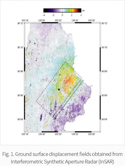
The Pohang earthquake provides a unique opportunity to constrain the static slip model of an earthquake in Korea using spaceborne InSAR observations, as surface displacement fields were successfully obtained by both descending and ascending orbits of the Sentinel-1A/B satellites. By collaborating with the Remote Sensing and GIS Lab at Kangwon National University, we undertook linear slip inversion to obtain a finite source model for this event using InSAR data. Our slip model reveals that a major slip associated with the event occurred in the northeastern part of the hypocenter, rather than in the southwestern part. In addition, its rupture dimension and mean slip are 5 km (width) by 6 km (length) and 15 cm, respectively. The InSAR data also show that no significant post-seismic deformation occurred after the event.