QUATERNARY GEOLOGIC MAPS BASED ON THE SURFACE DISTRIBUTION OF QUATERNARY SEDIMENTS, AND THEIR APPLICATION FOR CUSTOMIZED QUATERNARY THEMATIC MAPS |
The Quaternary is an important period in geologic time due to extreme climate fluctuations and modern human occupation. In Korea, the Quaternary geological map project began from the 2010s based on the Quaternary geologic age dating, sedimentary stratigraphy, and paleo-depositional environments of Quaternary sediments. The Quaternary geological map in Korea is divided into profile type and surficial type. The Quaternary geologic map in the 1:250,000 Busan mapping project illustrates the distribution of depositional environments during the postglacial surficial deposits, based on surficial type. Also, the 1:250,000 Busan Quaternary map partially shows the spatio-temporal distribution of sediments deposited during the Quaternary period. The map has principal geologic components as follows: (1) the surface distribution of Quaternary sediments (1-meter rule); (2) geologic information of buried Quaternary sediments based on borehole data. The Quaternary mapping of surficial deposits has been classified by colluvial, alluvial (including alluvial fan), fluvial (including fluvial terrace), lacustrine, coastal (including a beach, delta, dune, terrace, tidal flat), and reclaimed sediments, mapped in the 1:250,000 Busan mapping area. These domains are represented by consistent geomorphological features and typical assemblages of surficial deposits. For some domains, schematic cross-sections are provided to give an overview of the typical landforms and geologic information of buried Quaternary sediments based on borehole data. The 1:250,000 Busan mapping area covers 3 metropolitan cities, 13 cities, and 14 counties. The 1:250,000 Busan Quaternary geological map can meet academic, social, and economic needs as well as providing domestic geologic information, and it is possible to approach the concept of a customized Quaternary thematic map that can be used for public service following social demand.
Contact: Jin Cheul Kim (kjc76@kigam.re.kr)
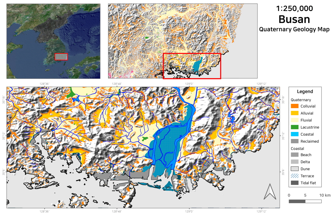
Fig. 1. Example of 1:250,000 Busan Quaternary geologic map.